About the Post:
Harappa, Mohenjo-daro, Dholavira, Rakhigarhi and Ganweriwala are the known major urban sites of the Indus-Sarasvati Civilization. In the previous post, we discussed about the information found in Mahabharata regarding Harappa; this post shall now reveal the plausible clues that are embedded in Mahabharata, about Rakhigarhi and Ganweriwala.
Sneak Peek:
The sequel series ‘TRUTH BEHIND THE DECLINE OF HARAPPANS’ aims at re-establishing the evident connection between the historical Harappans and the legendary Kurus. Part-1, 2, 3 and 4 gave an overview of the Kurus, the Harappans and the credible link between the two; this part-5 will share more information on the topic.
Rakhigarhi:
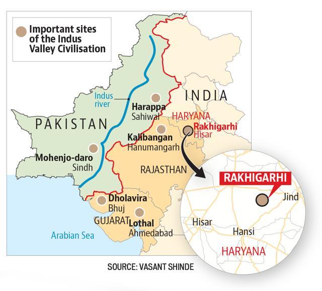
The Harappan site at present day Rakhigarhi is not only a major urban site, but also one of the oldest sites of the Indus-Sarasvati Civilization. Rakhigarhi, located in the Hisar District of Haryana (in India), is the biggest of the hitherto discovered Harappan sites; the size of this site is estimated to be a little more than 350 hectares. The chronology of Harappan sites at Rakhigarhi ranges from Pre (circa 4300 – 3300 BCE), through Early (circa 3300 – 2600 BCE), to Mature (circa 2600 – 1900 BCE) Harappan periods.

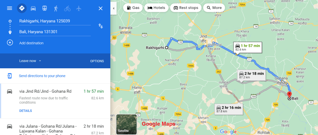
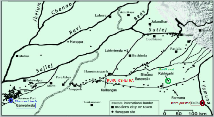
In the previous post (part-4), we learnt that Arjuna had instated Kritavarma’s son at the city called Martikavat in Kuru-kshetra (see Map-8), and had left the remaining wives of Kritavarma (who managed to survive the calamity) there. To the best of my knowledge, the critical edition of Mahabharata shares only this much information; however from other versions / sources, we get to know that ‘Bali’ was the name of this particular son of Kritavarma. One more important point to be noted is that Martikavat was an already existing city in the Kuru-kshetra region, at that time (circa 3102 BCE) when Arjuna established Bali there.
The present-day Harappan site of Rakhigarhi, owing to its size and chronology, could be the Martikavat City of Mahabharata days (circa 3250 – 3100 BCE), which was ceded by Arjuna to the wealthy remnants of Kritavarma’s family, who had migrated to the land of Kurus for good. Incidentally there is a village named ‘Bali’, situated about 80 kms to the south-east of Rakhigarhi (see Map-7); however I am not sure whether this data can be cited as a credible evidence in support of my hypothesis. Nevertheless I can’t help correlating this fact with the term ‘city-states’, found in the following information provided by Harappa.com, regarding the Integration Era / Mature Harappan Phase:
…………….. Perhaps even more important is the evidence for political and ideological integration of major settlements and the emergence of what may be termed “city states” (Kenoyer 1997a) ……………
Ganweriwala:
Ganweriwala, located deep in the Cholistan Desert of southern Punjab (Pakistan), is identified to be one of the major urban sites of the Indus-Sarasvati Civilization. This Harappan site, situated on the dry river bed of the Ghaggar-Hakra, is also roughly equidistant between Harappa and Mohenjo-daro; such a strategic location might have made it a regional capital well downstream of Rakhigarhi. Ganweriwala has not yet been officially excavated; probably it is the site’s proximity to the India-Pakistan-border-line that prevents the archaeologists from exploring its bronze-age mounds. However Harappa.com provides ‘Glimpses of Ganweriwala’, by quoting excerpts from Farzand Masih’s article ‘Ganweriwala – A new Perspective’, published in ‘Walking with the Unicorn’ (2018).
Ganweriwala was discovered in the late 1980s by Rafique Mughal, who had estimated its area to be over 80 hectares; a survey ten years later had it at about half that size. Regarding this dreadful discrepancy, Farzand Masih comments, “it is possible that some areas of the site are now covered by sand dunes and, perhaps, will be located during future explorations”. In any case, Ganweriwala was much larger than the dozens of other sites measured along the old Hakra riverbed by Mughal, about which there are accounts found in his book ‘Ancient Cholistan‘ (1997); I looked for this valuable document in Amazon.in, but it is currently neither available as a hardcover edition nor as a Kindle version.
Farzand Masih informs through his article that in recent years, a four-meter wide road was constructed through the middle of Ganweriwala to facilitate the movement of hunting parties from the UAE; he adds that though this is highly unfortunate, it did provide ready-made sections across the upper portions of the mounds (see picture below).

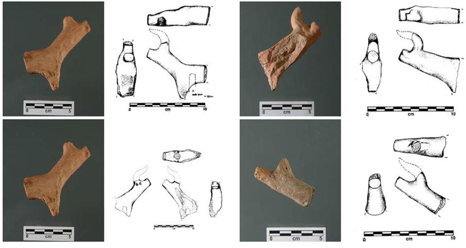
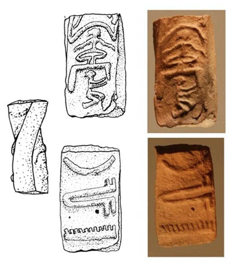
Ganweriwala, despite being the least excavated of the five large known ancient Indus cities, has yielded interesting artifacts; the meager treasure includes four unicorn figurines, a clay Harappan tablet depicting a seated meditative-figure, and a unique copper seal (thanks to harappa.com for the images, seen below).
Three significant maps found in the book ‘The Lost River’, authored by Michel Danino, proposes the three stages of reconstruction of Sarasvati basin’s hydrography, based on the distribution pattern of Early, Mature and Late Harappan sites. Out of these maps, the one pertaining to the Mature Harappan Phase marks the location of Ganweriwala near the point of Sarasvati’s re-appearance (see Map-8), beyond the dry segment of her lengthy course.
Farzand Masih informs that two carbon samples were collected from a sealed strata that pointed circa 2300 – 1900 BCE as a general dating of the upper levels of the Harappan site at Ganweriwala; this means that the lower levels might yield an even more older date (Early / Pre Harappan).
According to the Vana Parva of Mahabharata, River Sarasvati disappears at Vinasana and re-appears at ‘Chamsodbheda’; as per the Shalya Parva of Mahabharata, ‘Chamsodbheda’ is the holy tirtha where Lord Balarama and his numerous companions spent the first night of their pilgrimage. Hence I infer Ganweriwala to be either the sacred Chamsodbheda itself or a prominent settlement in / in the vicinity of Chamsodbheda. Since Ganweriwala belongs to the Punjab Province of Pakistan, there is a possibility that this site was situated in the Aratta / Panchanada region (refer part-4), during the Mahabharata days (circa 3250 – 3100 BCE).
Harappa.com declares that unicorn figurines, similar to those discovered at Ganweriwala, have not been obtained from any other Indus site except Harappa, Mohenjo-daro and Chanhu-daro. This valuable information seems to suggest that there was some kind of affinity among these four sites; moreover, from a piece of information shared by Kenoyer in one of his lectures, it is understood that some sort of trade-related connection existed between Harappa and Mohenjo-daro.
Closing Message:
We need to check if Mahabharata contains clues about Dholavira and Mohenjo-daro also; let us continue our research in the upcoming part-6.
End-Note:
Thanks for reading this post; please leave your feedback in the comment box below.
Check the Home page for the latest posts from our blog.
Browse the Blog page to find all the posts.
Visit the About page for the introduction to the blog.
Learn about the Research, Titbits, and Bliss sections of this blog.
To know the terms and conditions of this blog, please read the Norms page.
Go to the Contact page to message me and/or to find me on social media.
