About the Post:
Following is an excerpt from the article titled ‘The Past is a Divided Country‘, by Nayanjot Lahri for a journal named ‘Open’:
In 1947, as India and Pakistan came to be created along religious lines,…………………… Since the major sites of Harappa and Mohenjodaro were ‘lost’ to India, finding forgotten Indus sites in India became a priority area of research. How the play of politics and scholarship in connection with the discovery of Indus sites in India unfolded after 1947 is among the least known set of events relating to independence and Partition. Surprisingly, it is one in which it was not scholars who pressured politicians but men in high political places who pushed for research on the Indus Civilisation. It is a story that reminds us of Amalananda Ghosh. An officer of the ASI who went on to become its director-general, it was Ghosh who in 1950 began a systematic exploration of Bikaner along the dried-up bed of the Ghaggar river. Within two months, he found as many as seventy sites, fifteen of which yielded the same types of antiquities found at Harappa and Mohenjodaro. This is well known. But how did Ghosh’s survey take place?……………………………….
This post shall focus on Pakistan’s Mohenjo-Daro which was designated a UNESCO World Heritage Site in 1980, and India’s Dholavira regarding which nomination dossier namely ‘Dholavira: A Harappan City’ was submitted for inclusion in the World Heritage List for the year 2020.
Sneak Peek:
The sequels of this series have been speaking about the connection between the tangible Harappans and intangible Kurus of Mahabharata fame. What does the magnum opus Mahabharata say about Mohenjo-Daro and Dholavira? Read on to know more……
Mohenjo-Daro:

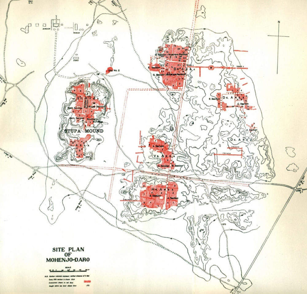
Mohenjo-Daro happens to be one of the largest cities of the age-old Harappan Civilization; this bronze-age archaeological site occupies more or less 300 hectares of land. Mohenjo-Daro is located in the Sindh Province of Pakistan and is situated a little to the west of River Indus, on the bank of an abandoned bed of the river. Most of the online sources announce that Mohenjo-Daro was built around 2600 BCE and was abandoned in circa 1900 BCE; however, I would like to present here the chronological details shared by Kenoyer, in his own words:
“Mohenjodaro site has many different occupation levels. The Harappa Phase is from 2600–1900 BCE. The Late Harappan Phase is from 1900–1300 or later. There is a Kushana period occupation that is seen in the area of the Stupa, dating to the 3rd to 4th century CE. Deep excavations and corings have found evidence of an Early Harappan level that probably dates to 3300–2600 BCE.”
Harappa.com provides exceptional data about the Indus-Sarasvati Civilization, which are seldom found in other online sources; let us see what it says about Mohenjo-Daro:
“………………………….Mohenjo Daro is ………………………………. not far from the very early human flint mining quarries at Rohri. The Indus may once have flowed to the west of Mohenjo Daro, but it is now located to the east. Here the Great Bath, uniform buildings and weights, hidden drains and other hallmarks of the civilization were discovered in the 1920’s. This is where the most unicorn seals have been found. Due to a rising water table, most of the site remains unexcavated, and its earliest levels have not been reached.”
Lakhanjo-Daro, situated on the bank of the Indus River, is another Harappan-era city that was discovered in 1986; recent excavations in 2009–2014 have shown that it is probably as big as Mohenjo-Daro. Lakhanjo-Daro is located in the Sukkur District of Pakistan’s Sindh Province, at a distance of about 100 km from Mohenjo-Daro. Lakhanjo-Daro is generally known as a contemporary of Mohenjo-Daro; however, according to a Wikipedia statement, the material-cultural-finds of the site indicate that it predates the Mature Harappan period.
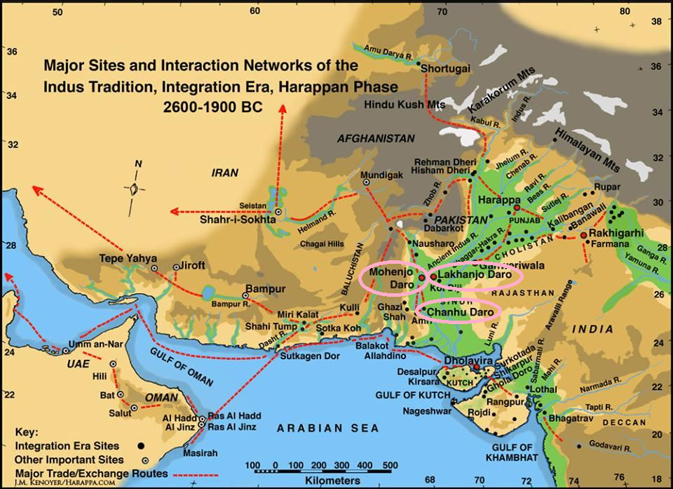
Chanhu-Daro, situated to the east of River Indus, is another important Harappan site; it is located about 130 km southwest of Mohenjo-Daro, in the Sindh Province of Pakistan. Chanhu-Daro, comprising three ancient mounds, roughly covers an area of about 6.3 hectares; however, it is opined that the site is much eroded and should extend on a much larger area beyond the limits of the three mounds emerging above the level of the surrounding plain. One of the scholarly papers that I referred to mentions Chanhu-Daro as the only Harappan site which does not have a citadel. Chanhu-Daro has given evidence of factories of various figurines, seals, toys, bone implements, and shell-works like bangles and ladles; so, it has been interpreted that it was a settlement with lots of artisans. Wikipedia states that the site was inhabited between circa 4000 and 1700 BCE; however according to Kenoyer, “Based on what we know now the site begins around 2600 BCE and continues to the Late Harappan as at Mohenjo-Daro, possibly to around 1300 BCE.”
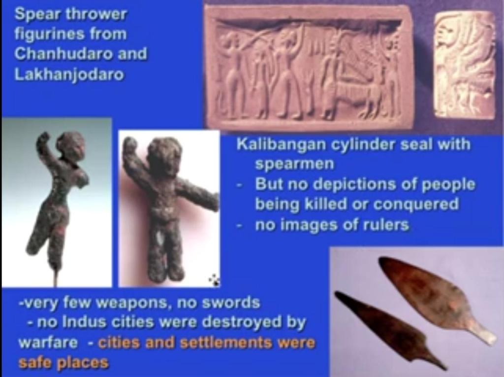
Pashupati Seal—the most popular Harappan artifact—was unearthed at Mohenjo-Daro; I have already decoded the seal, thereby identifying the depicted yogic figure as Jayadratha. As per Mahabharata, Jayadratha was the mighty ruler of Sindhu Kingdom (which was stretched along the banks of River Sindhu aka Indus) as well as its neighbouring dominions—the Souvira and the Shibi; Dussala, the only sister of the hundred Kauravas, was married to him. It is mentioned in Wikipedia that Roruka, identified with present-day Aror/Rohri (in Sindh), was the capital of Souvira Kingdom; Aror was the medieval name of the city of Rohri. Considering the proximity of Lakhanjo-Daro to Aror/Rohri, I guess it would be appropriate to determine that present-day Lakhanjo-Daro was the Aror/Rohri (i.e. the capital of Souvira) of the Mahabharata days. Moreover, the spear-thrower figurines from Lakhanjo-Daro and Chanhu-Daro seem to uphold Mahabharata’s statement (refer to the Raja-Dharma Parva) about the military habits of the Sindhus and the Souviras: “the Gandharvas, the Sindhus, and the Souviras fight best with their nails and lances“. Thus, in view of their location, size, and artifacts, Mohenjo-Daro and Lakhanjo-Daro might have been the respective capitals of the Sindhu and the Souvira; the much smaller Chanhu-Daro which is devoid of a citadel might have been an important industrial town in the Sindhu territory during or after the Mahabharata period (i.e. during or after circa 3250–3100 BCE).
Dholavira:
Dholavira, locally known as Kotada timba, is a Harappan archaeological site located in the Kutch District of Gujarat; the site has taken its name from a modern-day village 1 km south of it. Dholavira is one of the five largest Harappan sites; it is situated on the Khadir-bet/Kadhir-island in the Great Rann of Kutch. The 47 hectares (120 acres) quadrangular city lay between two seasonal streams, the Mansar in the north and Manhar in the south; it had an access to the sea prior to the decrease in sea level. Regarding the site’s chronology, Wikipedia states: “The site was thought to be occupied from circa 2650 BCE, declining slowly after about 2100 BCE, and to have been briefly abandoned then reoccupied until circa 1450 BCE; however, recent research suggests the beginning of occupation around 3500 BCE (pre-Harappan) and continuity until around 1800 BCE (early part of Late Harappan period).”

Dholavira is the only known site where stones were used on such a wide scale by the Harappans, for building a city; “though it followed some of the classical Harappan norms, its overall concept departed from everything we have seen so far”, writes Michel Danino. I would recommend reading “The Lost River” for a glimpse of the astounding unique aspects of Dholavira; of course, one can always visit YouTube for engrossing audio-visual stuff about the site.
The discussions about Dholavira in an earlier post did indicate the plausibility of its association with Lord Krishna, who was the maternal cousin of the Pandavas. Moreover, when I read Harivamsha (an appendix to the Mahabharata) for finding the location of the remains of proto-historic Dvaraka (Krishna’s now submerged city), it seemed to vaguely point to the in and around regions of present-day Kutch in Gujarat. In fact, the areas explored by Dr.S.R.Rao during his search for the submerged Dvaraka include Bet-Dwaraka, situated at the mouth of the Gulf of Kutch. Nonetheless, I do not want to dwell upon unconfirmed theories; I wish I could figure out the true story of Dholavira/Kotada timba sooner or later.
Closing Message:
This topic is conspicuously stretching beyond the estimated number of sequels and hence, we will have to continue the discussion in the inevitable part-7.
End-Note:
Thanks for reading this post; please leave your feedback in the comment box below.
Check the Home page for the latest posts from our blog.
Browse the Blog page to find all the posts.
Visit the About page for the introduction to the blog.
Learn about the Research, Titbits, and Bliss sections of this blog.
To know the terms and conditions of this blog, please read the Norms page.
Go to the Contact page to message me and/or to find me on social media.
