About the Post:

Few scholars, I know, doubt whether present-day Sri Lanka was the Lanka of the Ramayana days. Initially, I wondered how they nurtured such a suspicion, while the satellite images of Rama’s bridge connecting India with Sri Lanka are quite common on the internet. But when I researched this topic myself, I realised certain truths, and hence, I thought of writing this post to share my views.
Sneak Peek:

If what you see in this satellite image is not Rama’s bridge, then where is the real Ram-Setu? Does Ram-Setu still exist? Where is the real Lanka of Ravana? Continue reading this post to unravel the plausible truth………
Modern Sri Lanka:
Modern Sri Lanka, also known as Ceylon, is an island country in South Asia. It lies in the Indian Ocean, close to the south-eastern end of present-day Peninsular India; the shortest distance between the two is just 55 Km. It is said that “Taprobane” was the name used by the ancient Greeks—Megasthenes, Eratosthenes, and Ptolemy—to refer to the island now known as Sri Lanka. According to Wikipedia, the chronicle “Mahavamsa” states that the ancient city founded by the legendary Prince Vijaya in the land now called Sri Lanka was named “Tambapanni“; it adds that “Tambapaṇṇī” is a name derived from the Sanskrit word Tāmraparṇī or Tāmravarṇī (“the copper coloured”).
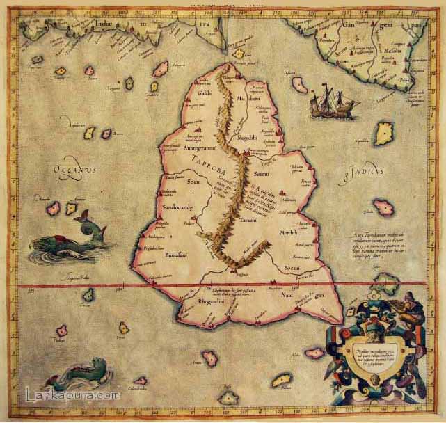
Valmiki Ramayana (one of the sacred epics of India) states that Rama, with the help of an army of vānaras (monkeys/forest animals), built a bridge to reach Lanka to rescue his wife Sita from Ravana—the mighty ruler of Lanka—who had abducted her in Rama’s absence. It has been widely believed for a long time that present-day Sri Lanka was the Lanka of Ravana; coincidentally, satellite images reveal a bridge that connects India with Sri Lanka. Although there is an argument that this bridge is a natural formation, there are claims that certain evidence indicates that it is man-made. Yet, owing to the discrepancies between the scriptural accounts of Ravana’s Lanka and the facts about modern Sri Lanka, researchers who believe in the historicity of Rama and Ramayana refuse to accept present-day Sri Lanka as Ravana’s Lanka.
The Ramayana Period:
As interpreted from some ancient Indian Puranas, Lord Rama was born in the 24th Treta-yuga of the ongoing Vaivasvata-manvantara and Valmiki—the author of Ramayana—was a contemporary of Lord Rama. It means Ramayana happened about 18 million years ago. Suppose this date is true, the geography of our planet during the Ramayana days was probably different owing to the sea levels, climatic conditions, and other aspects of that geological period.
Description of Ram-Setu:
The word ‘Ram-Setu’ of Sanskrit origin means “Rama’s bridge”. However, the one who constructed the bridge was Nala (a vānara), the son of the architect-god Vishvakarma. So, Ram-Setu is also known as ‘Nala Setu’. The English translation of Valmiki Ramayana by Bibek Debroy (Book 3, pages 31–32) states that uprooted trees and boulders were used for the construction of the ten yojanas wide and one hundred yojanas long Ram-Setu, and that “the radiant and grand bridge could be seen like a line drawn through the ocean.”
The Variable Yojana:
According to Wikipedia, the definition of Yojana found in Vishnu Purana includes the following equations:
2 Padas (feet) = 1 Vitasti (span)
2 Vitastis = 1 Hasta (Hand/Cubit)
4 Hastas = 1 Dhanu = 1 Danda = 1 Paurusa (a man’s height)
2000 Dhanus = 1 Gavyuti (distance to which a cow’s call/lowing can be heard)
4 Gavyutis = 1 Yojana
As per the concept of Maha-Yuga (aka) Chatur-Yuga, as a Yuga-Cycle progresses through the four yugas, the standard human height keeps decreasing. Since the formula for calculating the value of one yojana includes the average human height, I believe that the distance specified by the unit of one yojana probably keeps varying according to the standard human height of the concerned yuga within a Chatur-Yuga.
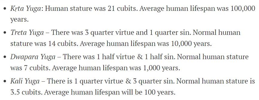
Rama lived during a Treta-Yuga. It is said that Treta-Yuga begins with an average human lifespan of 10,000 years and an average human height of 14 cubits. According to the current metric system, 14 cubits are equal to approximately 21 feet in which case one yojana of a Treta-Yuga would equal approximately 51 km and one hundred yojanas would equal approximately 5100 km. However, according to the ancient Egyptian royal cubit concept (the earliest attested standard measure), 14 cubits equal approximately 24 feet of the present-day metric system. Thus, I infer that one yojana of Ramayana days equals the modern-day measurement of more or less 59 km.
Tracing the True Lanka:

From the Valmiki Ramayana, we know that the Ram-Setu was 100 yojanas long and looked like a line drawn through the ocean. As per my calculations, the Ram-Setu built by Nala was probably about 5900 km long. In that case, if we can find anything on the Indian Ocean floor befitting the descriptions of Ram-Setu in Valmiki Ramayana, it is the Ninety-East Ridge (NER); it is identified as the world’s largest linear aseismic ridge. According to a research paper by Kolluru S. Krishna et al., the Ninety-East Ridge extends approximately 5600 km in the North-South direction from 34°S to 17°N. The research paper states, “Although numerous explanations have been proposed for the formation of the NER, it is widely accepted that the ridge was formed by Kerguelen hot spot volcanism when the hot spot was located beneath the Indian plate during the Late Cretaceous and early Cenozoic.” Thus, it could be understood that modern scholars have not yet actually figured out how the Ninety-East Ridge was formed. So, I believe that the Ninety-East Ridge marks the location of the real Ram-Setu. Most probably, the ridge served as the pillars (i.e. load-bearing components) of the bridge built by Nala for Rama; the upper portion (i.e. super-structure) of the bridge must have perished long ago.

B: The Ninety-East Ridge
C: The Broken Ridge
D: Islands on the Kerguelen Plateau
Kolluru S. Krishna et al. specify that the northern portion of the Ninety East Ridge (north of 10°N) is entirely buried under thick Bengal Fan sediments and that the southern part intersects the East-West trending Broken Ridge. Modern geologists say that Broken Ridge once formed a large igneous province along with the Kerguelen Plateau, but then got separated by the Southeast Indian Ridge when Australia and Antarctica started to separate during the continental drift. However, considering the arguments against the Continental Drift Theory, I wonder if this notion is correct. Even if the hypothesis is true, the separation process ended about 30 million years ago, implying Broken Ridge got separated from the Kerguelen Plateau long before the Ramayana period.

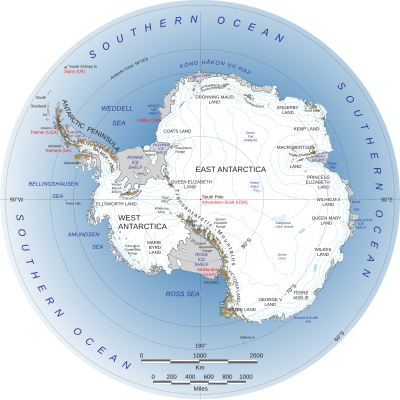
The Kerguelen Plateau is an oceanic plateau and a large igneous province on the Antarctic Plate, in the southern Indian Ocean. It is about 3,000 km southwest of Australia. The plateau extends more than 2,200 km in a northwest-southeast direction and lies in deep waters. The Kerguelen Islands (also known as the Desolation Islands) and the Heard & McDonald Islands constitute the two exposed parts of the Kerguelen Plateau. Ramayana specifies that the Lanka of Ravana was located in the South. And it is said that according to the Surya-Siddhanta (an ancient Sanskrit treatise in Indian astronomy), “the haunt of the rakshasa” (i.e. Lanka) was geographically situated on the imaginary line that ran through Avanti. The present-day Malwa region of Madhya Pradesh in India is said to be the Avanti of ancient times, and the pertinent longitudes pass through the Kerguelen Plateau. Hence, I initially thought Ravana’s city, described in Ramayana, was situated on the Kerguelen Plateau. However, much later, I realised that the Valmiki Ramayana specifies the breadth of Ravana’s island as one hundred yojanas (i.e. approximately 5,900 km as per my calculation). Thus, I finally inferred that Ravana’s city was probably situated in the landmass now known as Antarctica because the widest part of Antarctica is said to be approximately 5500 km across.

As per the Valmiki Ramayana (translated by Bibek Debroy, book 3, page 289), Rama told his wife Sita while returning from Lanka to Ayodhya—Rama’s city—in an aircraft, “O one with the beautiful face! Look at that tirtha on the ocean there. That is where we crossed over the ocean and spent the night. O large-eyed one! That is the bridge I constructed over the ocean, the abode of waters. It was extremely difficult to build and it was done for your sake. This is Nala Setu.” According to Bibek Debroy, the Sanskrit word ‘tirtha’ here means “a place where one descends into the water”. Therefore, the word ‘tirtha‘ here probably refers to the spot/shore Rama and his army reached after walking across the Ram-Setu. However, according to my research, the southern end of the 100-yojana-long Ram-Setu was apparently somewhere near Broken Ridge, and not anywhere near Antarctica. So, I think that there was most probably a navigable or passable path, like shallow sea areas dotted by islands or a land bridge or an ice bridge, between Broken Ridge (i.e. the southern end of Ram-Setu) and Antarctica (i.e. the ‘island’ where Ravana resided) during the Ramayana period.
Closing Message:
I am aware of the criticisms I may face for proposing such unconventional notions; scholars might state that my interpretations are pseudo-scientific. Nevertheless, I am not hesitant about discussing something I perceive as a plausible truth. By the way, if I come across supporting evidence for these notions, I will present it in a sequel to this article.
End-Note:
Thanks for reading this post; please leave your feedback in the comment box below.
Check the Home page for the latest posts from our blog.
Browse the Blog page to find all the posts.
Visit the About page for an introduction to the blog.
Learn about the Research, Titbits, and Bliss sections of this blog.
To know the terms and conditions of this blog, please read the Norms page.
Click Contact to send me a message or to find me on social media.

Ma’am,
Though your article is entertaining, I feel it may be that you have selectively collected facts to suit your hypothesis….🤔
LikeLiked by 1 person
Thank you, Sir, for stating that my article is entertaining.
LikeLike
Few things that bother me.
1. It is literally impossible to build a bridge of 5100 kms through the middle of an ocean without any land mass. The logistics is unimaginable without magic.
2. Continental drift is a plausible theory to consider even if we accept your hypothesis of the real Lanka.
3. Could an island near the current Tamrabarani river be the real Lanka?
LikeLiked by 1 person
The questions that you have raised are reasonable; I respect everyone’s opinion. Immense thanks for your feed back, Sir.
LikeLike
Madam, please check this out.
LikeLiked by 1 person
Surely will check this post suggested by you Mr.RL, and will get back to you. Thanks a lot.
LikeLike
Yes, Mr.RL. It is true that many scholars locate Ramayana-Lanka at the spot shown on the map, shared by you. They equate one yojana to appx. 1200/800 miles and thus arrive at this marked location in the Indian Ocean. However, I think I have made it clear in my post that the measurement marked by the unit of one Yojana plausibly is not fixed but varies with respect to the standard human height of the concerned epoch. Thanks for your continuing interest and sensible responses.
LikeLike
I meant to say 1200 kms / 800 miles
LikeLike
Can you pls show the calculation of yojna because when you said 51yojna i am confuse you said that it varies with life span of human and height so in that way if you show calculation that how 1yojna is equal to 51km then it make easy
LikeLiked by 1 person
First of all, thank you so much for your interest in my blog.
Yojana calculation depends only on human height and not on human life span; the calculation is as follows:
Formula:
1 Dhanu = a man’s height
2000 Dhanus = 1 Gavyuti
4 Gavyutis = 1 Yojana
Calculations for 1 yojana with respect to TRETA YUGA:
1 Dhanu = a man’s height = 21 feet (in Treta Yuga)
2000 Dhanus = 21*2000 = 42000 feet = 1 Gavyuti
4 Gavyuti = 4*42000 = 168000 feet = 1 Yojana
(1 feet = 0.000305 km)
Hence, 1 Yojana = 168000*0.000305 = 51.2064 km
Hope you are satisfied with my answer to your query.
LikeLike
Wouldn’t the Chagos-Laccadive Ridge be a better location if we think of Ujjain as the Meridian? Let’s say we use something akin the old calculations, we get 14km = 1 yojana, so 1400km = 870 miles. If 15km = 1 yojana, we have 932 miles. Diego Garcia island in Chagos is 1116km ssw of Kanyakumari.
So perhaps the Ramayana Lanka is somewhere between Maldives and Diego Garcia on the Chagos-Laccadive Ridge? The Ridge looks it would have something on the meridian with Ujjain.
LikeLiked by 1 person
Sorry Diego Garcia is 1116 miles ssw, not km.
LikeLiked by 1 person
It is true that most scholars locate Ramayan Lanka in or around the spot you have mentioned. However, my view is a little different. Your interest and opinion are much appreciated. Thank you.
LikeLike
Good stuff, though i don’t see a solid reason to discard any drift theory. As if it is dated back so long surely not only the sea level has changed, but volcanic/ earthquakes would have occurred during this while so the prime meridian might not be an accurate indicator. But have you research on Kumari kundam? there might be the missing link
LikeLiked by 1 person
Thank you so much for your feedback about this post.
I have not researched Kumari Kandam. The difficulty is that we do not have reliable references or information about Kumari Kandam.
LikeLike